Mapleton Canyon, Utah, Saturday, April 16, 2008
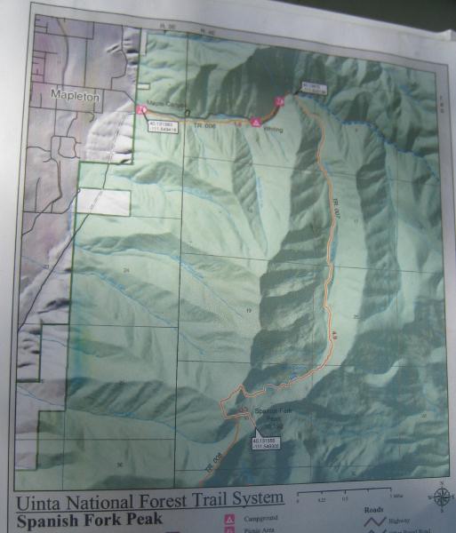
This is a map of the trail to Spanish Fork Peak. The trail is denoted in yellow. We took a trail denoted in blue that is east of, and parallel to, the Spanish Fork Peak Trail. On Friday I sent an e-mail announcing our hike plans, and only Irma Villasana came to the Oak Hlls 8th Ward Chapel at the appointed hour of 7 am. We first followed instructions from the "100 Hikes Utah" book in an attempt to find a trailhead to Spanish Fork Peak located 4 miles beyond the mouth of Spanish Fork Canyon, a trailhead accessible through a green gate on a dirt road - - there have been changes since the book was written in 2001, including current construction, and we saw no such trailhead. We then went to a "more popular" trailhead in Mapleton Canyon, which we knew of from a website. We parked the car at what we believed was Whiting Campground, but which was actually an equestrian lot connected to the Whiting Campground by a 1 mile trail. We walked the trail, came upon the large campground with a large, elongated asphalt parking lot with numerous campsites, and hiked to the east end of the parking lot (following the directions of a camper) to the trailhead. We followed this trail, noticing a pond to our right after a short distances, then ultimately came upon a fork in the trail - - we took the fork to the right, which took us up a pretty steep and infrequently used trail, which did not end at the top of a peak. After descending the mountainside we found a forest service worker, who told us the fork was a choice between a destination called Diamond Head and the trail we took. By that point we had already missed the trail to Spanish Fork Peak - - the turnoff to that trail was at the pont we had seen, although the turnoff was not indicated by a sign. According the forest service worker, the campground is a national forest campground, but locals treat is as there own, and seek to keep others out by making sure no maps or trail signs or posted. Well, it worked on us. What an outrage! This map was in a binder the forest service worker showed us.